Search This Blog

Saturday, 15 November 2014

Our Pre-Journey


                                      More on our pre-journey and more information about us...

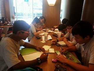
working hard in mac donalds :)
effort
endurance


Friday, 14 November 2014

Safety Precautions

Our locations on the Singapore map


More about the locations we travelled to

Click the links to find out where we went.
Pearl centre - location https://www.google.com.sg/maps/place/pearl+center/@1.275426,103.838165,15z/data=!4m2!3m1!1s0x0:0x41bd81a2eff41f25
Tiong Bahru post office - location
https://www.google.com.sg/maps/search/tiong+bahru+post+office/@1.286081,103.826958,16z/data=!3m1!4b1
Bukit merah west national police post - location
https://www.google.com.sg/maps/search/bukit+merah+west+neighbourhood+police+centre/@1.2822465,103.831398,16z/data=!3m1!4b1
Henderson secondary school - location
https://www.google.com.sg/maps/place/Henderson+Secondary+School/@1.285107,103.819525,15z/data=!4m2!3m1!1s0x0:0x567f4adbf392efec
My saviours church - location
https://www.google.com.sg/maps/place/My+Saviour's+Church/@1.292367,103.823552,15z/data=!4m2!3m1!1s0x0:0x50fe94c36c31a9b6
St Margaret's secondary school - location
https://www.google.com.sg/maps/place/Saint+Margaret's+Secondary+School/@1.320285,103.80985,15z/data=!4m2!3m1!1s0x0:0x23c2eabe724b905f
Bukit Timah fire station - location
https://www.google.com.sg/maps/place/Bukit+Timah+Fire+Station/@1.34915,103.770657,15z/data=!4m2!3m1!1s0x0:0x6ed4402dc6a32b12
SHATEC - location
https://www.google.com.sg/maps/place/SHATEC/@1.343709,103.750084,15z/data=!4m2!3m1!1s0x0:0xaf8a20b91c8190b0
Masjid Ar-Raudhah - location
https://www.google.com.sg/maps/place/Lembaga+Pentadbir+Masjid+Ar-Raudhah/@1.351672,103.755868,15z/data=!4m2!3m1!1s0x0:0x1b2405fc857a2fd3
Choa Chu Kang neighbourhood police post - location
https://www.google.com.sg/maps/place/Choa+Chu+Kang+Neighbourhood+Police+Post/@1.379432,103.751667,17z/data=!3m1!4b1!4m2!3m1!1s0x31da11c0a870081f:0xe17c8af83a44a48a
Punggol interchange - location
https://www.google.com.sg/maps/place/Punggol+Temp+Int/@1.403706,103.902243,15z/data=!4m2!3m1!1s0x0:0x794177313be07f2e
punggol north fire post - location
https://www.google.com.sg/maps/place/Punggol+North+Fire+Post/@1.398953,103.90821,15z/data=!4m2!3m1!1s0x0:0xd097b6feb17f0cf7?sa=X&ei=GKthVMvuFs-LuATbkIDAAw&ved=0CHQQ_BIwCw
punggol 21 community centre - location
https://www.google.com.sg/maps/place/Punggol+21+Community+Centre/@1.39556,103.912204,17z/data=!3m1!4b1!4m2!3m1!1s0x31da16023742e905:0x99cce38a1424dfc5
Hougang community centre - location
https://www.google.com.sg/maps/search/hougang+community+centre/@1.3609235,103.8916245,14z/data=!3m1!4b1
Change general hospital - location
https://www.google.com.sg/maps/place/Changi+General+Hospital/@1.340549,103.949542,15z/data=!4m2!3m1!1s0x0:0xd0d464b7d1c77552
St Andrews's community hospital - location
https://www.google.com.sg/maps/place/Saint+Andrew's+Community+Hospital/@1.335076,103.9132739,15z/data=!4m2!3m1!1s0x0:0xdb5497308f95bf9d
Bedok community centre - location
https://www.google.com.sg/maps/place/Bedok+Community+Centre/@1.324344,103.935822,15z/data=!4m2!3m1!1s0x0:0x986731c0bc3f4251
Marisa Stella high school - location https://www.google.com.sg/maps/place/Maris+Stella+High+School/@1.34224,103.878278,15z/data=!4m2!3m1!1s0x0:0x269ca57c0fa99eba


Checkpoint 1)Sketches and descriptions of Pearl Centre

 Pearls Centre

Observation and Analysis
> seems old due to the building's state
> Outram Park MRT located within a walking distance
  - the location of the MRT will allow citizens/ residents to conveniently by MRT as a mode of transport Pearl Centre
  - as it is within a walking distance, it would be convenient and easy for others to reach Pearls Centre quickly

> Several bus stops located nearby
  - buses will then serve as another form of transport for citizens to their destination such that it is more comfortable and effective for others.
  - bus stops are also located within a walking distance from Pearls Centre, therefore, it will be effective and quick for people who have alighted from the bus to reach Pearls Centre.

> Traffic Crossing has an "island" in the middle
  - it will allow people, especially the elderly, to take a breather and rest after crossing halfway through the road, instead of rushing them to walk the whole distance. This encourages the elderly to be cautious of their health first before crossing the rest of the road.
  - helps with safety of the people as well as they would not need to rush and dash across the whole road where they may risk their safety.

> Many stalls in Pearls Centre [ food stalls etc. ]
  - encourages business in that area therefore people would have jobs as stallholders to earn money, helping the economy as well.
  - serves as a place where nearby residents are able to get food for themselves. As money is used to get the food, it will also contribute to the economy. Also, it is a form of agriculture as people are getting food for themselves.

>Atmosphere is a bit rushed as people may be getting ready to go to work at that time.

As a building designer, I would want to repaint the building as well as change it's look as from the outside it looks quite dull and old.

Future.

As the demands from the increasing population gets more modernized, there is a possibility in the future whereby people will search for other places to get what they need or want. Many new malls are also being built as time passes, therefore there is a possibility whereby this place may get demolished to serve as other purposes that will fit into modern day demands. However, if it upgrades such that it meets modern day needs, it may not get run down or demolished.


sketch:

sketch for pearl centre, scale is 1:300

Checkpoint 2)Sketch and description of Tiong Bahru Post Office

Tiong Bahru Post Office

Observation and Analysis.
> HDB flats nearby seem old.
  - there is a possibility whereby the flats have existed for a long time and that they house mostly the elderly
> not visited by many residents
  - people are adapting to the modern world and are not using the mail that often, and would rather use a quicker and more effective way such as using emails. Hence, it may explain why lesser people are going to the post office that often.

> Many housing estates nearby [ HDB flats ]
  - not high rise buildings.
  - as many residents are living nearby, it would be easy for many of them to visit the post office and use their services.
  - the post office may also be placed here as it would be easy to render their services to the residents living there as they are nearby and close to them.

> Three bus stops are located within a walking distance
  - buses will serve as a mode of transport for other residents to get to the post office and it will also allow them to easily walk to their destination as it is only a short walk away.

> there is a construction site building another residential building beside the post office.
  - as the population increases, the amount of housing given also has to increase. The construction may have been held there as it would be convenient for the residents in that building to travel as well as visit the post office from time to time as both are within a walking distance.

> Atmosphere seems pretty peaceful and quiet as there are very little people around there

If I was an architect, I would like to use the HDB where the post office is in for other industrial purposes as there is a shortage of land in Singapore.
Future.

As time passes and upgrades, people may not be mailing letters through post offices and instead they would simply send it through emails or other messaging platforms. Therefore, the use of post offices are declining as time passes. As such, the post office may be closed down and used for other businesses or purpose. 


sketch:
sketch of tiong bahru post office, scale is 1:500


Checkpoint 3)Sketches and descriptions of Bukit Merah West Neighbourhood Police Post

Bukit Merah West Neighbourhood Police Post.

Observation and Analysis.
> roads have bumps
  - the bumps will control the speed of ongoing cars as it would be dangerous if cars were speeding in that area because there are many residents living in the flats next to the roads.

> placed beside Henderson CC
  - it will allow the public to see that the police post is working near and in conjunction with the community club
  - easier for residents nearby to access these government buildings such that it will be convenient and easy for them to come to and fro the NPP and CC as they are somewhat connected.
  - easier for the employees working in either the CC or NPP as some issues are alike and they are able to work together to solve the problems or obstacles faced.
> Hawker centre located within a walking distance from the NPP
  - Hawkers will be able to visit the NPP if anything wrong happens as it is within a walking distance and it would not take a long time to reach the NPP.
>Many HDBs within a walking distance from the NPP.
  - residents are easily able to walk to the NPP if needed to.
  - those working in the NPP are also able to effectively get to any residential problems as it is close to their access.
> The atmosphere was calming as there were not a lot of people who were visiting the NPP at that point of time
If I was an estate manager I would lave the NPP where it is as its location is appropriate for the residents and it saves the trouble for them to travel long ways to get there.
Future.
The NPP will most probably be in use in the future as the law still needs to be implemented no matter how much time changes or passes by therefore, in the future, there is a huge possibility that the NPP will still remain as such. However, due to the demands of rising population and the lack of land to support it, the NPP may also be forced to decline its size such that other industrial or housing buildings are built to meet the needs of the growing population.

sketch:

sketch of bukit merah npp, scale is 1:300