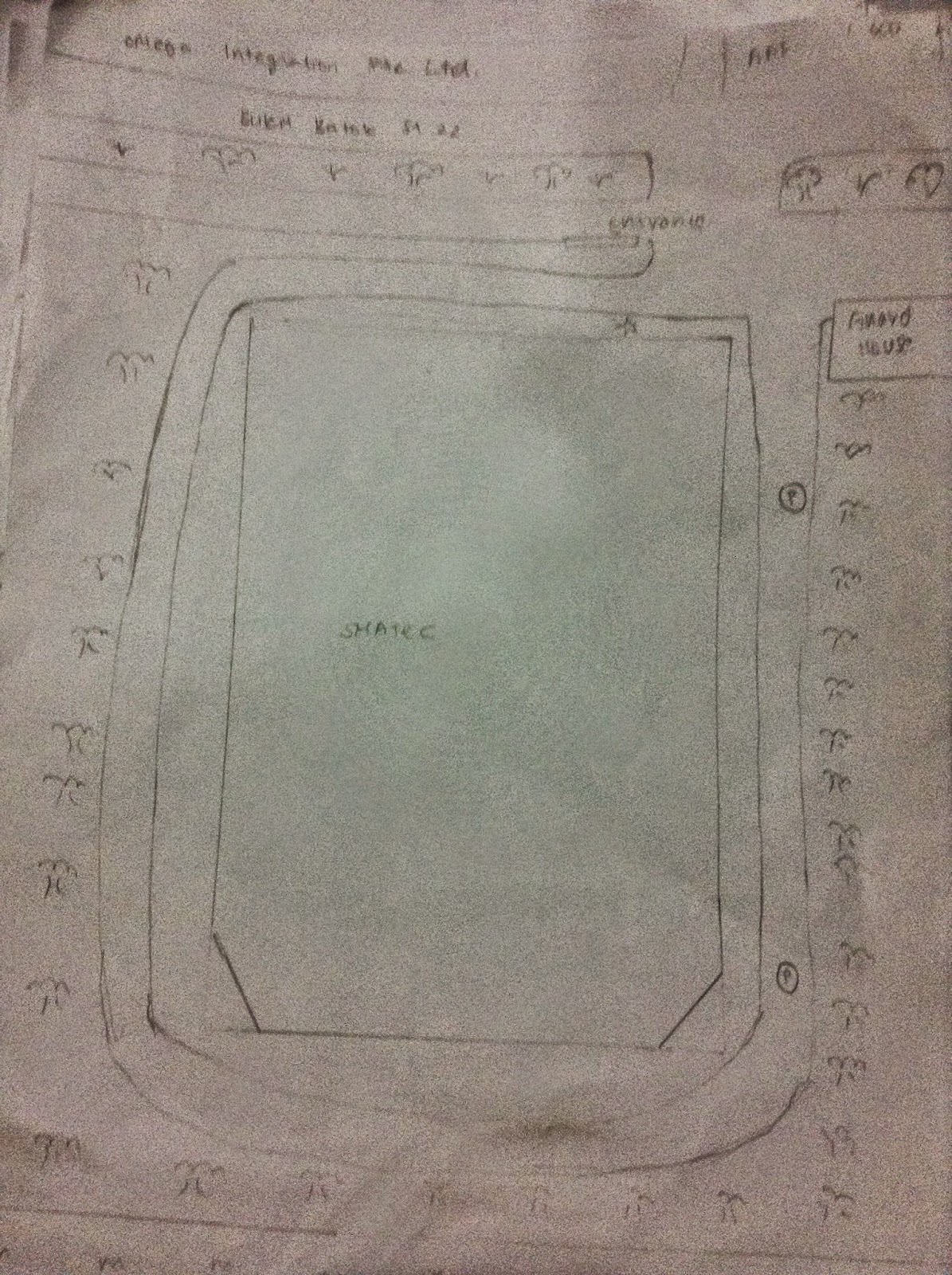
Search This Blog

Saturday 15 November 2014

Our Pre-Journey


                                      More on our pre-journey and more information about us...

working hard in mac donalds :)
effort
endurance


Friday 14 November 2014

Safety Precautions

Our locations on the Singapore map


More about the locations we travelled to

Click the links to find out where we went.
Pearl centre - location https://www.google.com.sg/maps/place/pearl+center/@1.275426,103.838165,15z/data=!4m2!3m1!1s0x0:0x41bd81a2eff41f25
Tiong Bahru post office - location
https://www.google.com.sg/maps/search/tiong+bahru+post+office/@1.286081,103.826958,16z/data=!3m1!4b1
Bukit merah west national police post - location
https://www.google.com.sg/maps/search/bukit+merah+west+neighbourhood+police+centre/@1.2822465,103.831398,16z/data=!3m1!4b1
Henderson secondary school - location
https://www.google.com.sg/maps/place/Henderson+Secondary+School/@1.285107,103.819525,15z/data=!4m2!3m1!1s0x0:0x567f4adbf392efec
My saviours church - location
https://www.google.com.sg/maps/place/My+Saviour's+Church/@1.292367,103.823552,15z/data=!4m2!3m1!1s0x0:0x50fe94c36c31a9b6
St Margaret's secondary school - location
https://www.google.com.sg/maps/place/Saint+Margaret's+Secondary+School/@1.320285,103.80985,15z/data=!4m2!3m1!1s0x0:0x23c2eabe724b905f
Bukit Timah fire station - location
https://www.google.com.sg/maps/place/Bukit+Timah+Fire+Station/@1.34915,103.770657,15z/data=!4m2!3m1!1s0x0:0x6ed4402dc6a32b12
SHATEC - location
https://www.google.com.sg/maps/place/SHATEC/@1.343709,103.750084,15z/data=!4m2!3m1!1s0x0:0xaf8a20b91c8190b0
Masjid Ar-Raudhah - location
https://www.google.com.sg/maps/place/Lembaga+Pentadbir+Masjid+Ar-Raudhah/@1.351672,103.755868,15z/data=!4m2!3m1!1s0x0:0x1b2405fc857a2fd3
Choa Chu Kang neighbourhood police post - location
https://www.google.com.sg/maps/place/Choa+Chu+Kang+Neighbourhood+Police+Post/@1.379432,103.751667,17z/data=!3m1!4b1!4m2!3m1!1s0x31da11c0a870081f:0xe17c8af83a44a48a
Punggol interchange - location
https://www.google.com.sg/maps/place/Punggol+Temp+Int/@1.403706,103.902243,15z/data=!4m2!3m1!1s0x0:0x794177313be07f2e
punggol north fire post - location
https://www.google.com.sg/maps/place/Punggol+North+Fire+Post/@1.398953,103.90821,15z/data=!4m2!3m1!1s0x0:0xd097b6feb17f0cf7?sa=X&ei=GKthVMvuFs-LuATbkIDAAw&ved=0CHQQ_BIwCw
punggol 21 community centre - location
https://www.google.com.sg/maps/place/Punggol+21+Community+Centre/@1.39556,103.912204,17z/data=!3m1!4b1!4m2!3m1!1s0x31da16023742e905:0x99cce38a1424dfc5
Hougang community centre - location
https://www.google.com.sg/maps/search/hougang+community+centre/@1.3609235,103.8916245,14z/data=!3m1!4b1
Change general hospital - location
https://www.google.com.sg/maps/place/Changi+General+Hospital/@1.340549,103.949542,15z/data=!4m2!3m1!1s0x0:0xd0d464b7d1c77552
St Andrews's community hospital - location
https://www.google.com.sg/maps/place/Saint+Andrew's+Community+Hospital/@1.335076,103.9132739,15z/data=!4m2!3m1!1s0x0:0xdb5497308f95bf9d
Bedok community centre - location
https://www.google.com.sg/maps/place/Bedok+Community+Centre/@1.324344,103.935822,15z/data=!4m2!3m1!1s0x0:0x986731c0bc3f4251
Marisa Stella high school - location https://www.google.com.sg/maps/place/Maris+Stella+High+School/@1.34224,103.878278,15z/data=!4m2!3m1!1s0x0:0x269ca57c0fa99eba


Checkpoint 1)Sketches and descriptions of Pearl Centre

 Pearls Centre

Observation and Analysis
> seems old due to the building's state
> Outram Park MRT located within a walking distance
  - the location of the MRT will allow citizens/ residents to conveniently by MRT as a mode of transport Pearl Centre
  - as it is within a walking distance, it would be convenient and easy for others to reach Pearls Centre quickly

> Several bus stops located nearby
  - buses will then serve as another form of transport for citizens to their destination such that it is more comfortable and effective for others.
  - bus stops are also located within a walking distance from Pearls Centre, therefore, it will be effective and quick for people who have alighted from the bus to reach Pearls Centre.

> Traffic Crossing has an "island" in the middle
  - it will allow people, especially the elderly, to take a breather and rest after crossing halfway through the road, instead of rushing them to walk the whole distance. This encourages the elderly to be cautious of their health first before crossing the rest of the road.
  - helps with safety of the people as well as they would not need to rush and dash across the whole road where they may risk their safety.

> Many stalls in Pearls Centre [ food stalls etc. ]
  - encourages business in that area therefore people would have jobs as stallholders to earn money, helping the economy as well.
  - serves as a place where nearby residents are able to get food for themselves. As money is used to get the food, it will also contribute to the economy. Also, it is a form of agriculture as people are getting food for themselves.

>Atmosphere is a bit rushed as people may be getting ready to go to work at that time.

As a building designer, I would want to repaint the building as well as change it's look as from the outside it looks quite dull and old.

Future.

As the demands from the increasing population gets more modernized, there is a possibility in the future whereby people will search for other places to get what they need or want. Many new malls are also being built as time passes, therefore there is a possibility whereby this place may get demolished to serve as other purposes that will fit into modern day demands. However, if it upgrades such that it meets modern day needs, it may not get run down or demolished.


sketch:

sketch for pearl centre, scale is 1:300

Checkpoint 2)Sketch and description of Tiong Bahru Post Office

Tiong Bahru Post Office

Observation and Analysis.
> HDB flats nearby seem old.
  - there is a possibility whereby the flats have existed for a long time and that they house mostly the elderly
> not visited by many residents
  - people are adapting to the modern world and are not using the mail that often, and would rather use a quicker and more effective way such as using emails. Hence, it may explain why lesser people are going to the post office that often.

> Many housing estates nearby [ HDB flats ]
  - not high rise buildings.
  - as many residents are living nearby, it would be easy for many of them to visit the post office and use their services.
  - the post office may also be placed here as it would be easy to render their services to the residents living there as they are nearby and close to them.

> Three bus stops are located within a walking distance
  - buses will serve as a mode of transport for other residents to get to the post office and it will also allow them to easily walk to their destination as it is only a short walk away.

> there is a construction site building another residential building beside the post office.
  - as the population increases, the amount of housing given also has to increase. The construction may have been held there as it would be convenient for the residents in that building to travel as well as visit the post office from time to time as both are within a walking distance.

> Atmosphere seems pretty peaceful and quiet as there are very little people around there

If I was an architect, I would like to use the HDB where the post office is in for other industrial purposes as there is a shortage of land in Singapore.
Future.

As time passes and upgrades, people may not be mailing letters through post offices and instead they would simply send it through emails or other messaging platforms. Therefore, the use of post offices are declining as time passes. As such, the post office may be closed down and used for other businesses or purpose. 


sketch:
sketch of tiong bahru post office, scale is 1:500


Checkpoint 3)Sketches and descriptions of Bukit Merah West Neighbourhood Police Post

Bukit Merah West Neighbourhood Police Post.

Observation and Analysis.
> roads have bumps
  - the bumps will control the speed of ongoing cars as it would be dangerous if cars were speeding in that area because there are many residents living in the flats next to the roads.

> placed beside Henderson CC
  - it will allow the public to see that the police post is working near and in conjunction with the community club
  - easier for residents nearby to access these government buildings such that it will be convenient and easy for them to come to and fro the NPP and CC as they are somewhat connected.
  - easier for the employees working in either the CC or NPP as some issues are alike and they are able to work together to solve the problems or obstacles faced.
> Hawker centre located within a walking distance from the NPP
  - Hawkers will be able to visit the NPP if anything wrong happens as it is within a walking distance and it would not take a long time to reach the NPP.
>Many HDBs within a walking distance from the NPP.
  - residents are easily able to walk to the NPP if needed to.
  - those working in the NPP are also able to effectively get to any residential problems as it is close to their access.
> The atmosphere was calming as there were not a lot of people who were visiting the NPP at that point of time
If I was an estate manager I would lave the NPP where it is as its location is appropriate for the residents and it saves the trouble for them to travel long ways to get there.
Future.
The NPP will most probably be in use in the future as the law still needs to be implemented no matter how much time changes or passes by therefore, in the future, there is a huge possibility that the NPP will still remain as such. However, due to the demands of rising population and the lack of land to support it, the NPP may also be forced to decline its size such that other industrial or housing buildings are built to meet the needs of the growing population.

sketch:

sketch of bukit merah npp, scale is 1:300

Checkpoint 4)Sketches and description of Henderson Secondary School

Henderson Secondary School

Observations and Analysis.
> there are bus stops right in front of the school and also across it
   - students or employees can take the bus as a mode of transport to reach the school
   -  buses will then add to the variety of modes of transport to reach the destination, which in this case would be the school
> there are HDB flats opposite the school
   - residents living in this area could admit their children into the school as it is within a short walking distance
   - it would be simple and effective for those living in this area to reach the school
> the traffic crossing has an island in the middle of the road
   - allows people, especially the elderly, to be able to rest and take a breather after walking through halfway across the road, therefore, it shows that the health of people, mostly the elderly, is important as by rushing the whole distance of the road, it may affect their breathing which may lead to health consequences.
    -  it serves as a safety point as people would not risk their safety to cross the whole distance of the road
> hawker centre within a walking distance from the school
   - students are easily able to get food from the hawker centre
   - the hawker centre will also benefit in terms of business as residents as well as students could buy food or drinks from the hawker centre 
The atmosphere can be chaotic as there are students, hawkers as well as passing vehicles from one point to another. Bus stops there are also usually filled with people waiting for the buses to arrive.
As a student of Henderson Secondary School, I would find it effective and convenient to travel to this school as there are plenty of resources and mode of travelling to get to this school.
Future.
This school may be renovated to look more modern and eye-appealing. Also, to match the modern-day needs, it may so change to a more future like school. However, due to the limited land space, there is a possibility whereby the school would move to another location.

sketch:
sketch of henderson secondary, scale is 1:1000

Checkpoint 5)Sketches and description of My Saviour's Church

My Saviour's Church

Observation and Analysis.
> Alexandra Primary School right next to it
  - the reason that a school is placed next to a church could be that people wanted the children to be religious and inculcate good deeds among on e another.
  - students from the primary school may tell their parents of the church next to the school, which may allow the parents to visit the church once in awhile if they are Christians
  - people who go to that church may admit their children into the school right next to it.
> Private estates / condominiums are located near the premises of the church.
  - the residents of the condo may find it efficient for them to visit the church as they live near it.
  - the residents may feel that they are more peaceful and safer at that area
> placed next to a canal
> Speed bumps to control the speed of ongoing cars to prevent an accident as there are residents crossing the road from time to time.
> Atmosphere is very calm and peaceful as there isn't that many people who come to this area.
If I was a pest exterminator, I would feel that it is appropriate that constant checks of the area should be conducted as the church is placed next to a canal. Therefore, in order not to risk getting any illness spread by pests, it would be necessary to conduct checks regularly.
Future.
There is a possibility whereby the church may close down due to its location, resulting in the lack of business. Its location may cause others not to know about the church and they would then attend others. However, due to the primary school next to it, there is a possibility that the popularity and  business of the church will strive as the students may tell their family of the church.
sketches:
sketch of my saviours church, scale is 1:40

Checkpoint 6)Sketches and description of St Margrets Secondary School

 St. Margarets Secondary School
Observations and Analysis.
> the school has a rich history of since 1842
> has bus stops within a walking distance from the school itself
   - busses will then be the mode of transport for the students up to their own comfort zones
   - students will find it simple to travel to their school as they could take the bus and walk a few minutes to reach their destination (school)
> many private properties / bungalows around the premises of the school
   - people living in that area are able to admit their children to this school and it would be effective for them as it would be easy to travel there.
   - the location  would then allow other citizens to get the house where they would have to buy it, hence contributing to the economy.
> overhead bridge with staircases
   - the overhead bridge will allow people, especially the students, the easily cross the road and taking in mind their safety. Therefore the bridge serves a purpose such that people would be safe when crossing the road, hence reducing the amount of accidents that may happen.
> car park nearby the school
   - the car park will allow parents of the children to send them to school by car as their mode of transport
> construction of a new building (most probably a house) across the school
   - this will allow other citizens to get hold of the housing at that area and hence boosting the economy
           
The atmosphere around the area seems peaceful as the area does not have much noise pollution due to its location.
If I was a bus driver, I will find it quite simple to find the school as it is quite big and located next to a busy road
Future.
The future of this school may not be affected as it has a large history, hence it is reasonable that the government would not want to take down the building. However, they may also move the school to other locations as time passes. The school will also adapt to the modern technological demands and will be more updated.

sketch:
sketch of st margrets secondary school, scale is 1:330

Checkpoint 7)Sketches and description of Old Bukit Timah Fire Station

Old Bukit Timah Fire Station

Observation and Analysis.
> Traffic light crossing has an island in the middle
    - allows people, especially the elderly, to be able to rest and take a breather after walking through halfway across the road, therefore, it shows that the health of people, mostly the elderly, is important as by rushing the whole distance of the road, it may affect their breathing which may lead to health consequences.
    -  it serves as a safety point as people would not risk their safety to cross the whole distance of the road
> several bus stops nearby which is within a walking distance
    -  buses will then serve as a mode of transport for people to get here
    - it is effective for others as they would not take a long time to travel from the bus stop to the old fire station.
     - adds to the variety of mode of transportation for the people
> now changed to a restaurant.
   - the reason could be that there may be too many fire stations such that it is needed for the fire station to be renovated so that it would meet the needs of the upgrading economy
   - people may not find the need to have many fire stations around, hence they changed the fire station into a restaurant
> many condominiums nearby
   - as there are many condominiums, it would house many residents as well. As many people are housed around that area, they would take note of the restaurants that used to be a fire station as it is a very convenient place to eat
> There is carpark nearby
    - cars can then be used as another mode of transport for others.
    - people could get here easily by car
> Bukit Timah Nature Reserve
   -  promoting a greener nature for the society as they would know of that place
The atmosphere around this area is calming as there is not much traffic or noise pollution around this area. It can also be quite dangerous as there is a possibility that wild animals such as snakes may enter the premises of the area stated above.
If I was a restaurant manager, I would take note if there are any cases of snakes or pests nearby as well as set up some traps so that it would not affect my restaurant business.
Future.
If businesses in the restaurants do not strive as much as time passes , there is a possibility whereby the restaurants/ old fire station will be demolished or renovated into a new building. However if its business strives, it may stay at its own location and continue as a restaurant.

sketch:
sketch of old bukit timah fire station, scale is 1:150

Checkpoint 8)Sketches and description of SHATEC

SHATEC

Observations and Analysis
> it is a private property
   - not everyone would have access to this area and building
   - the in-charge of this building may only want those authorised to be allowed into this building as it is in fact a school.
> there is only one accessible road to directly get  to SHATEC
   - it would be hard to transport ourselves in order to get to this area
   - there is a limited size and amount of vehicles that may enter
   - the reason being to this is that the higher authorities of the building would like to keep the building private and only used when needed
> construction works nearby
   - most probably building another office or industrial buildings to support as jobs for others
   - boosting the economy in terms of working and gaining jobs
The atmosphere in this area is very quiet and eerie as there is close to no people at that area. The area is also very excluded from the roads as well as HDB flats. Very little people would pass through this area.
If I was a tourist who is in Singapore to attend this school, I may find it hard to find this school as it is in an isolated area. Also, it may be hard to find the school by travelling by bus or MRT as there are no bus stops or MRT stations nearby. There is a possibility whereby if the mode of transport is taxi, the taxi driver would not know where this school is located.
Future.
The building may in fact get moved to another more appropriate location which will allow it to be more visible to others who wish to get to the school. However, if no one is admitted into this institution, it may get demolished to get replaced for another building which will meet the modern day demands of the changing society. This embellishment could also be caused due to the limited land space in Singapore.
sketch:
sketch of SHATEC, scale is 1:600

Checkpoint 9)Sketches and description of Masjid Ar-Raudhah

Masjid Ar- Raudah

Observations and Analysis.
> there are 2 carparks within a walking distance from the mosque ( beside it and in front of it )
   - people can easily travel by car as their mode of transport to the mosque and convenient for them
   - it is also convenient that there are 2 carparks as there is a possibility whereby some lots in the carpark are taken, hence by  having 2 carparks, it increased the chances of getting your car parked.
> there are also bus stops placed within a walking distance from the mosque
    - people, mostly residents, will also be able to travel to the mosque by bus, which adds to the variety of transports that we can take
    -  as it is within a walking distance, it would be simple for residents or people who live nearby to be able to reach the mosque in a few minutes after alighting from the bus at the bus stop.
> traffic crossing does not have an island in the middle.
   - this may risk the safety of the people, especially the elderly with breathing problems as they would be forced to rush across the whole distance of the road, not minding that they have breathing problems.
   - people may also risk their safety by rushing across the road to reach the other side within the time limit. Hence, there is a possibility whereby they may get into an accident while crossing the road.
> many housing estates/ HDB flats which are within a walking distance from the mosque
   -  residents living around this area would then be able to visit the mosque quickly by walking for a few minutes too conduct their prayers
   -  convenient for the residents to travel to the mosque up to their comfort zone
> construction works being conducted nearby the mosque
   - the construction works may cause a havoc to the people praying due to the noise pollution nearby\
   - the construction may also bring about more people to the mosque as the end product may be either an industrial office building or a housing estate.
The atmosphere in this area is lively and have a lot of people passing by as it was time for the Muslims afternoon prayers and there is a bus stop nearby. Also, there is a nearby neighbourhood which makes it convenient for the Muslims living around the area to go to the mosque to do their prayers.
if I was a elderly living near this area, It would be hard for me to rest due to the constant noise produced by the constructions, attributing to noise pollution.
sketches:
sketch of masjid ar-raudah, scale is 1:600

Checkpoint 10)Sketches and description of Choa Chu Kang Neighbourhood Police Centre

choa chu kang neighbourhood police centre

observations and analysis
>It is very noisy as there are many roads around the police centre used by many people at all times of the day
-residents living nearby may find this very annoying especially at night when they are trying to sleep and it is very noisy.
-residents walking around the police centre may be in danger due to the lack of street lights at night which may increase the amount of car accidents around the area.
-residents may find a sense of security as they have a police post nearby

>There is a community center nearby
-Residents or senior citizens can visit there with a sense of security as there is the police post nearby


>There are not many traffic lights nearby
-this is not elderly citizen friendly as they will have to jaywalk
-the road is mostly straight thus making is risky as people can start speeding along this road

The atmosphere in this area is quiet and calm except from the noise coming from the construction site nearby. There is the occasional buzz every Sunday which will come from the Church which makes it hard for the construction site to finish as they would have to stop every a Sunday

If I was a race-car driver, I would have mixed feelings about this area as the straight road implies a great area for racing. However, the police post nearby makes me think twice about speeding near this area in fear of getting a fine.

Future. In the future I feel that there should be more speed bumps and there should be more traffic lights nearby to allow the elderly to cross safely.

sketch:
sketch of choa chu kang NPP, scale is 1:400

Checkpoint 11)Sketches and description of Punggol Interchange

Punggol Interchange

observations and analysis
> MRT/ LRT station next to the interchange
   - people are able to travel longer after changing from bus to MRT/ LRT
   - convenient as people would not need to travel that long to exchange from bus to MRT/ LRT
   - adds to the variety of modes of transport being able to be taken within that area.

> Many stalls selling snacks or drinks in the interchange
   - stallholders will be able to establish their business by the purchase of snacks and drinks from people.
   - location of stalls are also appropriate as many people would gather and be around that area while waiting for their buses. Hence, if they feel tired and need some refreshments, they are able to purchase them from the stall, therefore establishing and helping with the business.

> Many HDBs found around the premises of the interchange
   - it would be convenient for the residents to be able to travel to the interchange or MRT/LRT station as they are of a walking distance
   - the chaotic environment due to the noise pollution caused at the interchange may affect the peace and livelihood of those living in that area.
 
> Railings connecting from the interchange to the MRT station stalls
   - those who are in need of support, probably the elderly, would be able to walk carefully with the help from the railings as a form of support
   - the railings could also be used as handles such that if those with respiration problems need to take a break, they could also use the railings as handles for support to allow them to rest.

> Bike Park
   - people are able to cycle to the interchange and safely park their bikes at the bike park
   - cycling would then serve as another mode of transport available for the residents


> Construction works nearby
   - the construction works may bring about more noise pollution to the interchange and buildings around it, hence affecting the environment
   - the developed building may hose more residents in the future, which will enable them to use the interchange as well as the MRT/ LRT stations
 
>  Ramp connecting the interchange with the MRT/ LRT station
    - those who are in wheels such as bicycle or wheelchair would then be able to travel up or down by the ramp instead of carrying the object itself, which would be inconvenient for them

The atmosphere around the area is generally peaceful but may be affected from time to time due to the arrival and departure of trains as well as the ongoing constructions.

If I was a spy, I would feel that the area would be a conducive place as there are many spots to not be noticed by people and it is also effective in terms of any sudden escape as there are multiple choices of transport to get away.

Future.
As technology gets more advanced, there is a possibility whereby the use of buses will decline. Hence, lesser people would use buses as their mode of transport.

 sketch:
sketch of punggol interchange, scale is 1:1150

Checkpoint 12)Sketches and description of Punggol North Fire Post

Punggol North Fire Post

Observations and Analysis
> there are many bumps along the road
   - allow the control of speeding cars as it may be dangerous for residents or pedestrians

> railings along the sides
   - those who are in need of support, probably the elderly, would be able to walk carefully with the help from the railings as a form of support
   - the railings could also be used as handles such that if those with respiration problems need to take a break, they could also use the railings as handles for support to allow them to rest.

> carpark nearby
   - cars will serve as a mode of transport for others as well
   - has easy access to the inner buildings

> Many lightings such as lamps
   - the lamps will then allow residents to be able to see more clearly in the night time and be cautious of their steps :)

> School nearby
   - residents may admit their children to the school as it is within a near walking distance
   - provide educational purposes to the residents as well

> Traffic lights to cross each road but there is not an island in the middle
   - this could be a safety precaution as people may rush across the whole road and end up into an accident or get injuries if they are careless
   - the elderly and those with respiratory problems would also be forced to strain themselves to cross the road within time limit

The atmosphere is quite peaceful as the fire post is located at the void deck of a HDB flat. Also, not many people passed by that area which allows it to be quiet and calm. There is also very little noise pollution or distractions in that area which may contribute to the factor whereby the atmosphere is peaceful

If I was building designer, I would like to design the HDB flats such that people would notice them much more easily.

Future.
The fire post may be moved to another more open area compact to the compact space now. The open area will then allow them to work in a more spacious and conducive environment.

sketch:
scale 1:600

Checkpoint 13)Sketches and description of Punggol 21st Community Centre

Punggol 21 Community Club

Observations and Analysis.
> LRT station nearby
   - allow convenience as a mode of transport for residents to easily travel from one location to another

> Speed bumps on the road which allows speeding cars to slow down.
   - crucial as people may get into accidents or suffer from injuries if a car is speeding

If I was a resident living nearby, I would be delighted as there are many facilities that the community club offers.

future
The community club is developing further and will soon be able to provide more facilities to make sure that the citizens leaving nearby have a good source of exercise and fun.

sketch:
sketch of punggol 21 community centre, scale is 1:400

Checkpoint 14)Sketches and description of Hougang Community Club

Hougang Community Center

Observations and Analysis.
>Carpark
-This carpark is beside the Community center which makes for easy excess from the back and side gates. It also allows other to park their car's and spend more time there
>Overheadbridge
-This prevents the disabled people to use this bridge to cross towards the Community Center. Instead the disabled will have to use more effort to travel further and less accessible for them
>HDBs and Terrace housing
-It is weird how the terrace houses are on the other side whilst the HDB's are right beide the community center
-Could be because there are more people who are living in the HDB that will visit the community center as compared to those who live in terrace houses

If i was a disabled person, i feel that I would rather stay at home than go out to visit the community center, as the amount of time and effort wasted is not worth is

Future.
I hope that in the future the overhead bridge will be remodeled so that there will be ramps and possibly the carpark can change into a multi-story car park to save space.

sketch:
sketch of hougang community centre, scale is 1:100


Checkpoint 15)Sketches and description of Changi General Hospital

Changi general hospital

Observations and analysis

> schools nearby, might ensure safety to the children as in case of emergencies, the hospital is just nearby and can attend to any serious injuries sustained if anything happens.

> Many car parks nearby so it would be much easier for the people to access the hospital itself
 - another mode of transport for many visiting the hospital

>location of the hospital is quite badly located as it is beside a intersection at simei avenue and it might be quite hard for the cars or other vehicles that are in a rush to turn into the hospital, therefore it might hamper the rescue progress in case of emergencies.

> Many houses located around the hospital so it would be easier for the citizens to travel to the hospital in case of emergencies.

> Traffic lights are located at each junction to ensure safety around the bends of the road

The atmosphere around the hospital is quite quiet as there are few roads around there except for a junction. This helps the patients in the hospitals get regular rest and breaks, which is a plus point.

If I was a doctor or someone working in the hospital, It would be quite hard for me to travel to the hospital if I do not have a car and am taking public transport as there is very few bus stops around and the closet mrt station is simei station which is relatively far.

Future: more bus stops and a new mrt station would be nice for the people working in the hospital.

sketch:
Scale 1:1000


Checkpoint 16)Sketches and description of St Andrews Community Hospital

St Andrews Community Hospital

Observations and analysis

>This is a bunch of hospitals close up together
-The location where the hospital is placed is very convenient as if there are emergencies, the hospital is right on the main road and beside an expressway as well.

>The way to go to the hospital is to turn in after Changi General Hospital
-Its very secluded and might be quite hard for some people to locate

>Only one road leading to the hospital so it might be quite hard for cars or ambulances to access the building in case of an emergency.

>Beside Changi general hospital so it would be hard for the hospital to get patients as they would be more likely to travel to Changi general hospital with it being at the front of the St Andrews Community Hospital.

The atmosphere is very peaceful as there are very few roads around the area so it would help the patients in the hospital get better rest.

If I worked at the hospital, it would be hard for me to get to work as it is very secluded and there is only a road leading towards it.

Future
 -There should be more roads to the hospital and it should not be in a secluded area but instead brought out to the main road so it is more easily accessible

sketch:
Scale 1:600


Checkpoint 17)Sketches and description of Bedok Community Centre

Bedok community centre

Observation and Analysis

> Near the main road and its facilities are easily accessible. There are many housing estates around the community centre so it would be easier for residents leaving near the community centre to entertain themselves or keep fit using the facilities the community centre provides.

>There are many Bus stations and a mrt station close to the community centre itself. This would make it easier for people to travel here to take part in the activities the community centre holds.

The atmosphere is noisy as it is beside the main road and it may affect those participating in the activities the community centre.

If I was a resident who lived around the area, I would participate more in the facilities they offer in the community centre to keep myself fit.


sketch:
Scale 1:400


Checkpoint 18) Sketches and Descriptions for Bartley Secondary School (closed)

Observations and Analysis
-placed between some buildings hence it may be difficult to fins it
 This may be due to the school heads wanting the location to be peaceful and away from the roadside so that learning will not be affected by the noise pollution produced at the roadside

- there is a bump along the road leading to the school\
 This factor is crucial as it allows speeding cars to slow down as it is within a school zone, drivers have to be extra careful such that they will not accidentally hit any crossing students

- there are some bus stops nearby
 Buses will then be a choice for the students to choose a mode of transport they will want to use to get to school

 The atmosphere at the school seems quiet as there are not many students around. It also could be due to the location

If I were a resident living there, I would like to admit my child to the school as it is peaceful and convenient to study there

 Future
The future of the school could be that it will be more technologically advanced due to the technology time nowadays always improving. As time passes, it will also have to change with the time and get more advanced as well. The population of the school may also increase due to the growing population of Singapore

Scale 1:600

Checkpoint 19)Sketches and descriptionn of Maris Stella High School

Maris stella high school

Observations and analysis

>located near the main road so it might be easier for parents driving cars to turn in to drop their children in school

>Has many bus stops and bartley mrt station is nearby so many students can travel to school much more conveniently

>Sound pollution might be a problem as the school is beside the main road and might make much noise which would distract the students in the school from studying or participating in their activities.

If I was a student in Maris Stella High school, I would hope to see more road crossings around the school so it would be safer for more students to get to the school

The atmosphere can be quite noisy at times due to the number of vehicles traveling and the noise is projected to the school.

sketch:
Scale 1:1000

Reflection from our team leader :)

Jared's Reflection
This hike was really unique and interesting as most of our traditional ways of exploration requires us to use a map and a compass to carry on with our tasks.  
however as we have gotten more modernized by technology we stop restricting ourselves from using just a map and compass and so i feel that it was great. implementing all of these. I feel that the experience from allowing each other to have the chance to lead was phenomenal as we got to see the younger ones taking charge at certain locations. The team work also allowed my group to bond better as a team thus allowing us to have fun along the journey. All of us have learnt not to only just plan a route but to also plan it wisely.We have visited areas in Singapore that one would rarely travel to thus allowing us to get more experience about Singapore. The aim of my group was to go out and gain experience and have fun and as a leader I am glad to say that we have achieved that goal. Overall this will be an unforgettable event and that I hope for more such activities to come out more often.

Thursday 13 November 2014

Reflections from our members

Jun Shen's Reflection
I find that this journey was really enjoyable and that we learnt a lot if i had the chance to do it again, i will. I gained a lot of useful experience and that i can use this experience o further teach my juniors in the future

Wednesday 12 November 2014

Reflections from our members

Ari's Reflection
During this competition, I was very interested how the team would be successful in the end. Everyone was very tired but after we had lunch, things started to get interesting. In the end, we had completed most of our checkpoints and were top 5 among all the schools. Our team mates collaborated and put in their efforts and worked as one therefore i learnt that, through teamwork and endurance, we can achieve anything!

Tuesday 11 November 2014

Reflections from our members

Casey's Reflection
The whole competition from start to end was enriching and fulfilling for many of us as we learnt different skill sets and when to apply them to the designated situations. We were certainly tired at times but the group members, constantly pushed each other and we managed to make it to the end. When I was leading my team, they were cooperative no matter what mistakes I made and they were willing to help out. I would have prepared much more before the competition if I had a second chance and continue helping out the team in ways I can manage. Without cars and phones, it would really be hard to navigate as this is the 21st century and many of us rely on out phones to help us, without cars it would take a much longer time to reach our destination, ( I would have thought it was obvious). If given the  chance, I would like to participate in this activity again.

Reflections from our members

Imroatus' Reflection
Even though our journey was tiring, it was fun going through it as a team.we started the journey with some of us not having breakfast yet we started with a high spirit.At first I thought that we could not make it,however with motivation and perseverevance from each other we made it! Thanks to Casey for pushing us when we walked slowly. While leading the north areas,I did'nt have the confidence in leading the team but with the teams spirit to win,I felt that I should not disappoint them and I tried my best to lead. It was also a great first time experience leading as I have always no confidence in leading a team. In my opinion,to improve the journey,we should have taken lesser time to do sketches of the places and to not take our own sweet time to go to each checkpoints. At the beginning I thought that I won't be a great help to the team as I don't know anything about exploration. However with the help of the team,I managed to learn new skills like how to get the mgr and bearing. I really really enjoyed going through the journey with our team. I think that it would be a lot more challenging and takes more time if there was no phone or car allowed. I have also learnt and explored more about places in Singapore that I'm not quite familiar with. Not only that, I also learnt that the purpose of this exploration challenge is not all about finding the checkpoint and wanting to win,its also about having fun with the team members. Overall,it was a great and memorable first time experience and the journey would not have been fun if the team is not there to motivate each other.We couldn't have made it if not for the team spirit and each other.I really think that we make up a great team!:)

Reflections from our members

Aneesa's Reflection'
Our journey as a group was not an easy one. As a group, we sacrificed and tried our best. From the start, (prep) we stayed back alot to revise and prepare to be prepared of the journey ahead. On the day itself we were unsure if we could do it or not but we pushed through. There were times on the day itself where we were hungry, exhausted, and had no motivation to pull it through. However with some perseverance and more motivation, we  as a group, fought to the end together. Personally, at first I felt really unsure but in the middle, I felt that we should be courageous upon any obstacles faced. Therefore, that feeling helped me push throughout the whole journey. Once we completed, I felt a rush of accomplishment and happiness as a group as we, together, finished it.
As we were taking turns leading the area, thetr was always a concern within us as we may not be familiar with the area and there is always a possibility that we may get lost. All of us helped one another while they led through each area.
Through this journey, I learnt that exploration is not focused on the checkpoints or characteristics itself, but it is also important that we enjoy ourselves, and we did :) So, as a matter of fact, I would like to go on this journey again.
However, I would want to improve on my mood and how I faced obstacles such that I will be more optimistic as well as find a faster and more effiective mode of transport.
Through this journey, I also feel that we have bonded more as a group. Although we are from the same CCA, we do not communicate much with one another everyday. Therefore, through this journey, we also established deeper relationships with one another. As a group, I find that we enjoy ourselves together and we have good teamwork with one another.
If there was no form of modern technology allowed, I personally feel whereby we may have more obstacles to face and the effectiveness when travelling will also be affected. We may also not be updated to the modern technology skills of finding our way like for an example using Google Maps.
In conclusion, I feel that this journey has been an enriching one, despite the hardships and obstacles. I really, sincerely enjoyed it :)